|
September 2010 - Hiking to Reflection Canyon
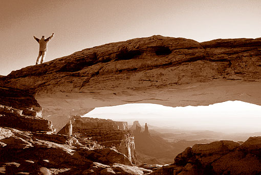
In April 2006 National Geographic published the article "Glen Canyon Revealed" with a picture of Reflection Canyon, a side canyon of Lake Powell. The image of Michael Melford not only fascinated me and many other photographers, but also immediately the search for the location of the view point began. It did not take long till you could find the coordinates of the location on the internet. The problem was that a longer boat ride on Lake Powell was necessary to get to the Reflection Canyon. But even then the uncertainty remains if you would find a way in the steep sandstone walls to climb from Lake Powell to the top of the hill in order to reach the right photo spot.
By boat or on foot?
To go by boat to the photo spot would mean to rent a fast motorboat at least for 2 or 3 days, if not longer - that would be quite expensive. Therefore I looked up the photo location on a map and came to the conclusion that it should be possible to hike to Reflection Canyon starting from Hole-in-the-Rock Road. The Hole-in-the-Rock Road is a 55-mile dirt road that starts north of Escalante and leads through the Grand Staircase- Escalante National Monument from West to East, ending high above Lake Powell. The end point of the dirt road is in the Glen Canyon National Recreation Area, an area that more or less surrounds Lake Powell.
Hole-in-the-Rock Road
The Hole-in-the-Rock Road was built by Mormons in 1880 to colonize the territory in the Southeast from Escalante. They believed to reach their goal on the other side of the Colorado River, the area where Bluff is situated today, within 6 weeks, however, the journey took six months. End of November 1879 they started with 250 men, women and children, 80 wagons and 1,000 head of cattle on their way through a barren, almost impassable terrain. It took 2 weeks to the gorge of the Colorado River. For six weeks the men then were working on a way over the sandstone cliffs down to the River. With dynamite and cutting tools they built a crevice along a steep path, called Hole-in-the-Rock. Huge boulders were moved and the crevice widened that the wagons could pass. Ropes secured the wagons when they were lowered to the Colorado and placed on rafts. After that it took another 10 weeks for a strenuous journey in winter conditions to reach Bluff. A memory plaque embedded in red sandstone reminds of this pioneering work.
Planning the hike
When searching a route from the Hole-in-the-Rock Road to Reflection Canyon, it was obvious to me that the trailhead for the Llewellyn Gulch would be the appropriate starting point for such a hike. With the help of Google Earth and DeLorme I planned the waypoints for my GPS route trying to stay at the same height as long as possible. I tried to avoid crossing deeper washes and canyons, because it could be rather strenuous and it could also be hard to find a safe way out of a deeper canyon. The one-way distance of my planned hike was about 14 km (9 miles) over rough pathless terrain and with some canyons to cross or to work around.
You can download the Waypoints (.gpx) of my planned hike.
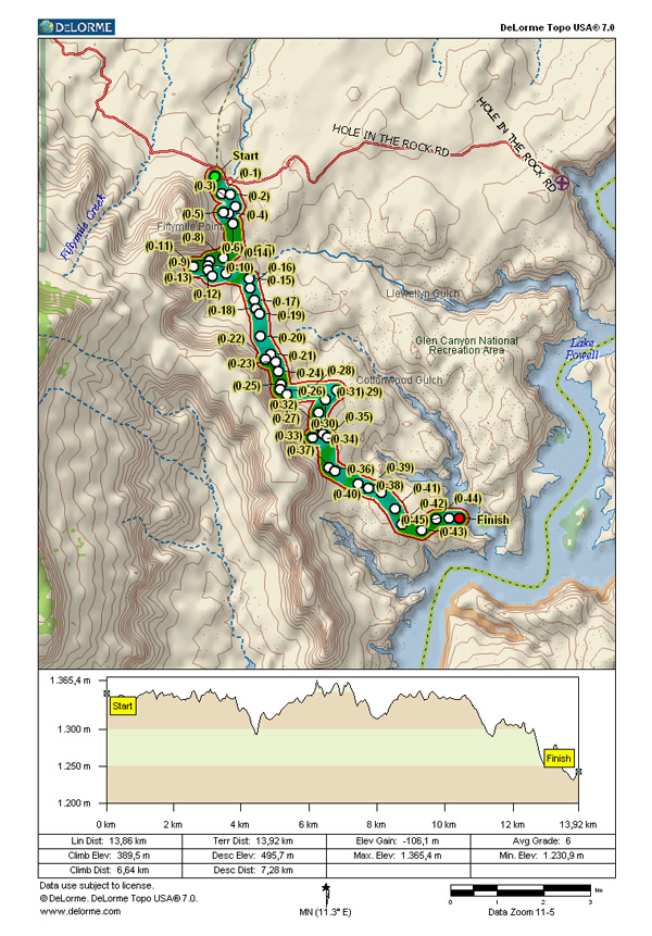
The terrain height profile of my tour shows that there is not a big difference in elevation along the hike, but the route is continuously going up and down. Only at the end of the hike, just before reaching Lake Powell, I have to descend about 100 m in altitude to get to the photo location - and I have to ascend on my way back. My investigations in the internet revealed no evidence that someone had tried already to hike to the location where the photo of Reflection Canyon has been taken - I would be the first one to try.
Rough road to the trailhead
In September 2010 it was time to realize my plans. Although strong thunderstorms recently had damaged the Hole-in-the-Rock Road, my rented Jeep Liberty 4WD was the right car to get to the trailhead. At mile marker 30, near Red Well, the dirt road was partially washed away and a 4WD was necessary to bypass through a deep sand hole.
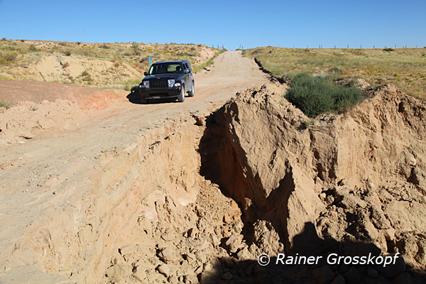
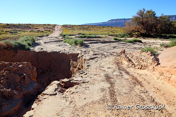
I had a free permit from the BLM in Escalante to stay at the trailhead for 2 nights. However, I had the impression that the Rangers did not really understand what I planned to do, because apparently no one tried this route before. In the BLM office a few photos hung out to show (and warn) how hard the Hole-in-the-Rock Road was damaged. These warnings unsettled me at first, but in a local jeep rental they convinced me that I should have no problems passing the washouts on the dirt road with my Jeep Liberty. And they were right.
I spent the first night at the end of the Hole-in-the-Rock Road, high above Lake Powell. The last very rough and rocky 5 miles of the road were no problem for my Jeep. Years ago I failed twice to reach the end of the Hole-in-the-Rock with rented SUVs. However, the first time I parked my car and hiked the last 5 miles to Hole-in-the-Rock. Therefore I was already familiar with the place, but I always wished to take pictures at sunset and to stay overnight.
Although I already knew the view down on Lake Powell, I was fascinated. The view at Lake Powell from Alstrom Point near Page is probably the more impressive scenery, but here at the Hole-in-the-Rock you can feel more the wideness and remoteness of the area - ultimately what I am looking for on my travels in the USA.
By late afternoon there was another family arriving with their boat on Lake Powell and they came up the steep path to the sandstone cliffs high above the lake. When the family was gone again, I was alone at this historic site.
I was quite alone with me to enjoy a beautiful view in the last rays of the setting sun,
Starting the hike
The next morning I drove back a few miles to the trailhead of Llewellyn Gulch, just below the cliffs of Fiftymile Point. It was another sunny and hot day, expecting temperatures above 30 degrees Celsius (90 degrees Fahrenheit). Around 10 am I started my hike equipped with my photo backpack and 6 liters of water.
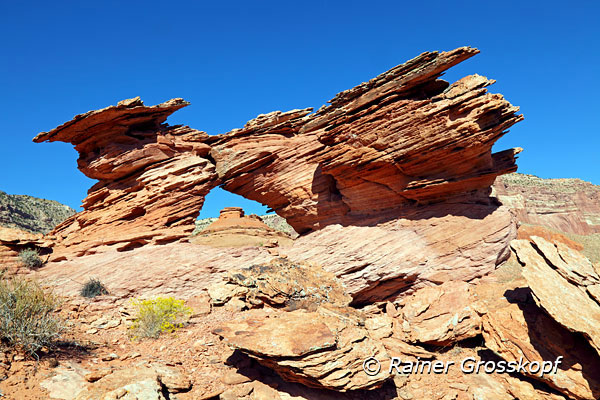
I followed my waypoints as planned and could avoid passing all the deep washes and canyons crossing my route. I also managed to avoid crossing the Llewellyn Gulch by hiking close to the cliffs where the Gulch begins as a sandy wash. I drank water regularly, had short breaks and otherwise followed my route in a moderate speed. On the way I saw a couple of Arches - maybe they were still undiscovered?
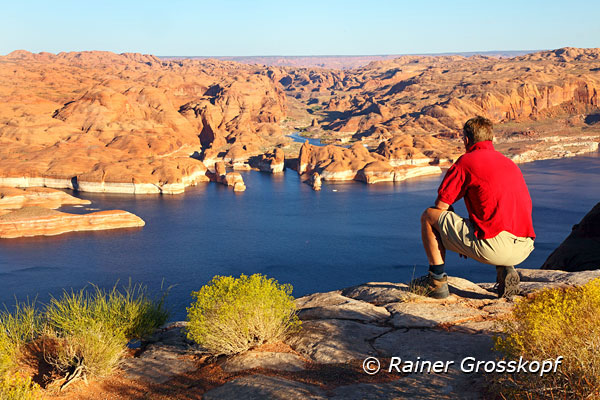
However, I soon realized that I would not make it to the view point in about three hours, as expected and planned. Sometimes I hiked on slick rock, but most of the time on rather sandy ground covered with sage brush, which was scratching on my legs constantly. But it was too hot to zip on the long pants - and it would not have helped anymore because my legs had already been scratched totally. Finally, I needed more than 4 hours until I got to the view point above Reflection Canyon.
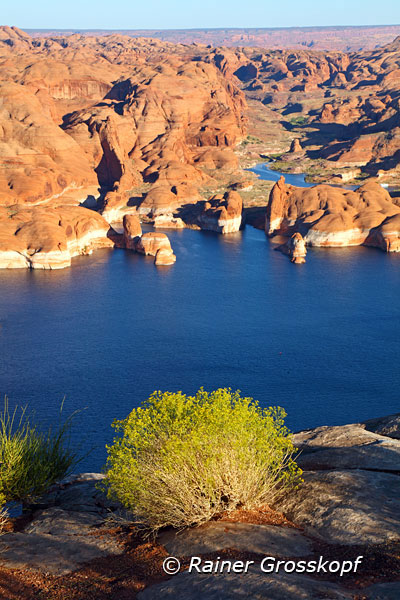
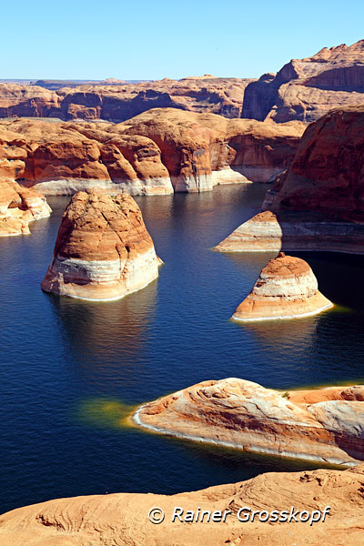
High water level in Lake Powell
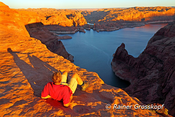
At first I was disappointed. The view was not like the one I was hoping for and it did not corresponded to the photo I had seen in National Geographic. The water level of Lake Powell was significantly higher than in 2006, when the photo was taken. The beautiful S-shaped course of the canyon was not well pronounced, because the sandstone rocks were much deeper in the water and formed only small islands.
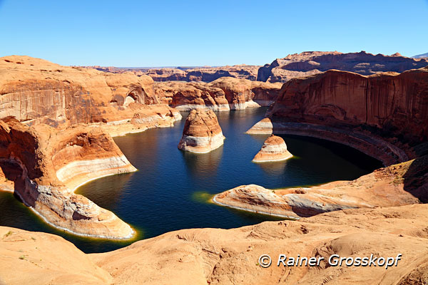
Too bad, but I had not thought of the impact of the water level on the scenery. I took a few photos and tried to descend on the steep sloping rock wall to reach another site. But that was rather dangerous, although one would ultimately end up in the water when slipping. On one of these trips along the rock wall I got lost a bit and suddenly recognized that I did not know where I had started and where I had left my photo backpack. With some difficulties I was trying to find a route to the top of the sandstone hill, from where I finally discovered my photo backpack and then descended to it.
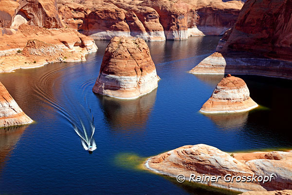
Every now and then a boat was passing through the canyon. It's a strange feeling when you see the boats, which came via a very simple way and have all kind of comfort on board, while I came here by a strenuous hike through a completely secluded area.
Despite some disappointment about the high water level of Lake Powell that did not allow me to take the planned photos, I was rather satisfied. I had done the hike and now I was sure that my considerations and planning were correct - you can reach the photo location on foot. Someday I have to come back again and take a picture when the water level is lower.
After resting for a while I wanted to eat something because so far I had only drank water. But the mixture of nuts, raisins and chocolate balls had become an unappetizing melted mass - I refused to eat it.
A strenuous hike back
After about an hour, around 3 pm, I started my way back. Sunset would be at 7:30 pm and about half an hour later it will be dark, so I had about 5 hours for the hike back to my car. I would have liked to stay longer to wait for the late afternoon light, but I was a bit restless because the first part of the hike to Reflection Canyon took longer than I had planned. And the hike back to the car will certainly be harder and will even take more time.
Soon on my hike back I realized that I came forward much more slowly than expected. I was pretty exhausted and needed a break more often than on the way to the Canyon. I also had the feeling that I had to go up and down more often than in the morning when I still was rather fresh. The continuous up and down when crossing small canyons or large washes consumed my forces and my rests became longer. I cannot remember that I ever was so exhausted on a hike. I also tried to shortcut and crossed deep washes instead of trying to find a way around, but the strain climbing out on the other side of the wash again forced me to take a break
The periods between the breaks became shorter and shorter and I was first thinking about what I would do if I did not make it to the car before darkness. Fortunately, I had all necessary equipment with me to spend one night outdoors. I had a light bivouac sleeping bag with me, still 2 liters of water and something to eat. Around 7 pm I still had not reached Llewellyn Gulch and I realized that I would not make it back to the car before darkness. This realization led to even more frequent and longer breaks, but I also kept on walking further and further.
I was rather exhausted and every time I crumbled out of a wash I had to take a break and wondered whether I should just stay over night. But realizing that I still had water, which certainly was over 30 degrees /Celsius) warm now, while just a few miles away there probably was some cold beer in the cooler in my car, inspired me to keep going. Fortunately, a three quarters full moon rose high on the horizon and gave enough light that I could find my way. Only if I had to cross a deeper wash I turned on my headlamp to prevent me from stumbling.
When I had almost made it to the car, I finally got another little shock. My GPS suddenly did not work! Fortunately, the GPS only failed at the last waypoint. The arrow pointing to the next waypoint did not move and constantly pointed in the same direction. Also the distance information did not change and I could not turn off the GPS either. Luckily this was not so dramatic because I just had to find the Hole-in-the-Rock Road which was about 500 meters away. I switched off the GPS by taking out the batteries, but after switching it on again the GPS still did not work. The next morning I tried the same procedure, and suddenly the GPS was working again.
It was already after 9 pm when I reached Hole-in-the-Rock Road completely exhausted. At some distance I saw the reflected moonlight on the windshield of my car. I had finally made it and my hope proved true: the cooler contained only water, but the beer had an excellent drinking temperature - even the second and third beer. Then I just laid down in the back of my car and fell asleep.
A lesson for the future
Next morning when I reflected upon my hike, I did realize that probably my biggest mistake was that I had not eaten. I drank approximately 5 liters of water during my hike, and thus my body lost minerals and electrolytes by sweating. This deficiency has ultimately led to the attacks of weakness that made it so hard for me to do the hike in a reasonable time.
>> More pictures
|