Up to now I was twice at the Adeii Eechii Cliffs, but both times in the same area. My first visit there was in September 2010 and you find the respective report here. During my second visit in March 2012 – I reported in my Travel & Photo Blog – I tried to find some other interesting sandstone formations but without success – I searched in the wrong area.
After these two visits to the Adeii Eechii Cliffs, I wanted to go to a slightly more distant area this time, because I had received a note that there should be the rock formations I was looking for. While several photos of these rocks were published in the Web, their location was kept as a secret, probably to avoid that other photographers would go there. The whistleblower is probably not interested to be published here, and therefore I will not name him (or her).
Preparation
When I planned the route to the new destination in the cliffs, I decided to take the same well-known route I drove several times before, and try to continue on the road further southeast to the new area. I had to pass a high-voltage line which I had seen on my former trips, and continue for another two miles. The whistleblower had proposed a totally different route coming from the opposite direction, which he drove during his visit of the region.
Since my former route was familiar to me and I had already been close to the power lines, I would try my route. However, during the preparation of the route I could see in Google Earth that the road was easy to detect before and after the high-voltage lines, but could barely be seen for half a mile near or below the power lines. I assumed that below the power lines the road crossed a rocky and rough terrain, and there was a certain risk that I could not continue, depending on my rental car’s off-road abilities.
Trip to the region to explore
In May 2013, I was in the area. My rental car was a Jeep Patriot with high-clearance and 4WD that seemed to be usable for the planned tour. Once again, I went up to the visitor center of the Navajos in Cameron to ask for permits for my tour because I planned to stay overnight. And once again the Navajo didn't know where I wanted to go. He showed me a folder with pictures of some areas in the Navajo reservation, and asked me where I planned to go to? I told him that I had permits for the Adeii Eechii Cliffs before and I could do all the paper work. He excused himself that he did his job only since a few days and was happy that I would take care of filling out the permit applications. I paid my 15 US$ (2 days and 1 overnight), and he passed me with a handshake.
The route begins near the Cameron Trading Post, just north of the bridge over the Little Colorado River. I knew the road already well from my former tours, and I drove pretty fast on the flat and easy road. After about half an hour, I passed a hoodoo, where I once had parked my car – this was the last well known place on this track for me. Shortly thereafter, the so far rather flat road became very rough, as assumed from the aerial pictures in Google Earth. The road passed a rocky and rough terrain going alternately up and downhill and the ground changed between sand and rocks. Under the pylons of the power lines it was not always easy to identify the track of the road. I stopped several times to orient myself, before I decided for the direction. I drove slowly because I was afraid of getting a flat tire on the rocky ground with sharp edges – my rental car had highway tires. I could not use a flat tire in this secluded area. But after creeping through rough and rocky terrain for half a mile, the track was again clearly visible and led over flat and somewhat sandy terrain. Soon I came to the final destination where I should leave my car.
I saw some cairns on a hill and that was a clear indication for me that I am at the right place. Also the GPS confirmed that it was time to park the car. Some older tracks were leading off the main track in eastern direction – also a hint that others parked here before. I parked my car in a small hollow, because I did not want that the car could be seen from the main track.
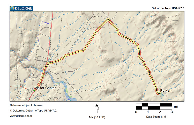
The following map was created with DeLorme Topo USA 7.0 and shows the driving route from the Visitor Center to the place where I parked my car. The track (.gpx) can be downloaded.
Hiking to the cliffs
About 2 miles to the east, I could recognize two areas with this reddish sandstone with the white patterns. I took the tripod, my photo backpack, the GPS and a bottle of water and marched towards the red sandstone massive. Although I had to walk up and down through badlands, the hike was not very exhausting despite the temperatures of more than 80 F, even now in the late afternoon.
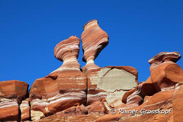
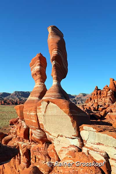
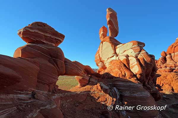
I hiked towards the northern sandstone area and when I finally passed a small hill I stood in front of the sandstone massive. Instantly I recognized the two hoodoos on top of the massive that are usually named “Crazy Ducks” - I was at the right place. I climbed to the hoodoos and used the warm afternoon light to photograph the two ducks from various viewpoints.
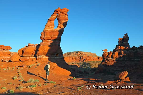
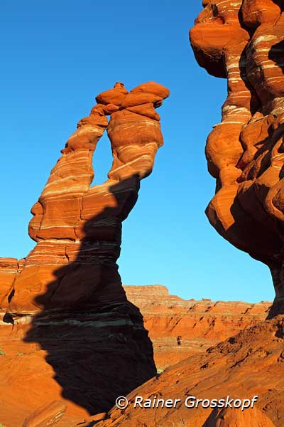
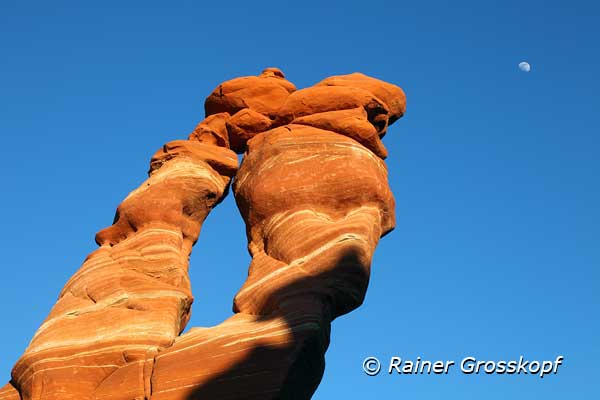
But it was not long until sunset and so I went on searching another conspicuous rock formation called “Eye of the Needle”, which I suspected here. But the search was not successful and I decided to climb again to the top of the sandstone massive to get a better overview. I was pretty sure to find the “Eye of the Needle” in this area because I had seen a treacherous shadow in Google Earth - but there was no “Eye of the Needle”. However, I should have checked my GPS-data then I would have realized that I am still a bit away.
I let the eyes wander over the other sandstone area, half a mile southeast. Yeah, suddenly I saw the “Eye of the Needle”. It must be pretty big, because the “Eye of the Needle” was clearly visible, although it was approximately half a mile away. Ten minutes later I stood at the foot of the huge needle, which surely was 20 meters high. I took several photos when I recognized that the sun was near the horizon.
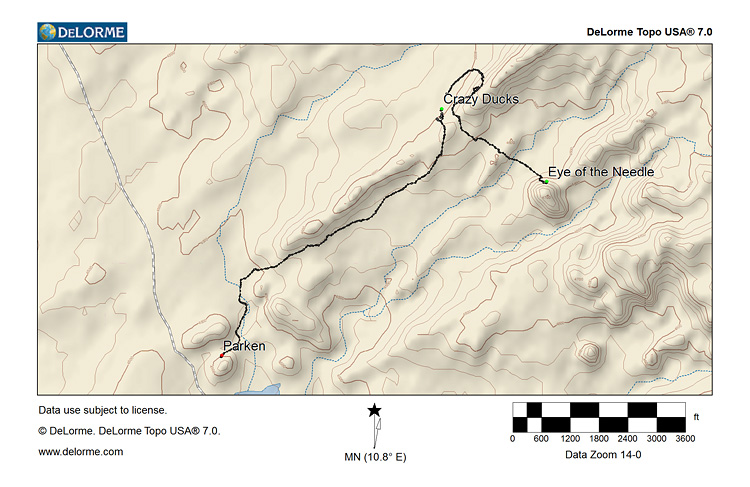
The following map was created with DeLorme Topo USA 7.0 and shows the short hikes from the parked car to the cliffs. The track (.gpx) can be downloaded, however it might be a better idea to investigate the area on your own - there may be other interesting sandstone formations.
There was no more time, to explore the area, but for the time being I was happy with my explorations. As the cloudless sky promised no dramatic sunset, I use the last light of the day, to hike back towards the car. Back at the car I prepared it for sleeping - minutes later it was dark.
The next morning I had overslept the sunrise, which perhaps would have brought better light for the “Eye of the Needle”. But no matter, the Adeii Eechii Cliffs have definitely more interesting sandstone formations to offer - I certainly will come back.