|
May 2009 - Angel Arch and All-American-Man
For a long time the Angel Arch was at the top of my hiking list. Some years ago I tried to get a walk-in permit to hike to the Arch and back in one day, but I failed because the Rangers didn’t give me a permit. Either all permits were really issued, or the Ranger didn’t believe that I could make the hike in one day, because it was already 11 a.m. when I asked for the permit. However, I decided to hike at least to the Peek-a-boo campground to get an impression of the trail. Usually you go there by car (4WD) but without permit you don’t get the code number for the padlock at the gate – so I had to walk. The spur road followed the Salt Creek which was completely dry and sandy at this time of the year. The track was rather narrow and twisting and I tried to imagine how I would drive this sandy road – full power at the sandy parts in order to reach the next part with hard and solid ground. Because of the deep sand, which made walking difficult, I had some respect for the track. I could not know at this time, that the track would look completely different some years later when I would drive there with my 4WD to the campground.
Planning the hike
A few years later my plans solidified. Finally, I wanted to buy lightweight trekking equipment that shouldn’t be too expensive. The equipment should be rather light because I would take 2 cameras with me, several lenses and a tripod – that’s already a lot of weight. The complete backpack for 2 or 3 nights shouldn’t weigh more than 20-25 kilos – that’s the pain threshold. On the other hand, the equipment should not be too expensive, because I assumed that I probably would not use it too often. A lightweight one-man tent (1.4 kg), a self-inflating mat (400 g) and a light sleeping bag (700 g), suitable for temperatures down to 5 degrees, were a good start. But I would need additional equipment for cooking and for water treatment, a first aid kit, and so on. I planned to buy a few things in the U.S., at REI in Denver, such as dry food, a spirit stove and a few things that we think we need only when we see it in the store.
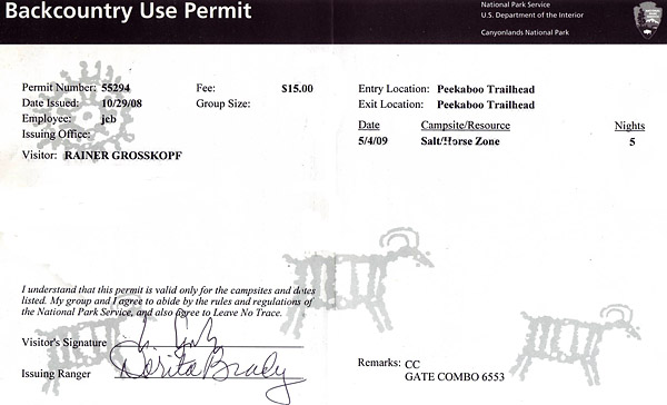
Already in autumn of 2008 I got my permit for the hike in the Salt Creek Canyon in the Needles District of Canyonlands National Park. At that time I was the only one who had applied for a permit yet, and I had no restrictions on the choice of campgrounds. However, I planned my "base camp" for all the time on the campground at the junction of Salt Creek and Angel Arch Creek. From there I could easily hike to Angel Arch at sunrise and sunset, and also a day hike to the All-American-Man pictography was possible.
My plans come true
End of April 2009 I flew to Denver, for the first time with quite cumbersome luggage. I had all the camping equipment in a travel-bag, such as tent, sleeping bag, shoes, hiking poles, backpack and the tripod. The rest of the stuff was in a trolley suitcase, in particular cloths and things I would need when staying in a motel. Finally, I had my big camera backpack with the photo equipment and a laptop.
My rental car was a Nissan Xterra with 4WD high and low and with good ground clearance. I was quite happy with the car and felt well equipped for my planned trips. The first days of my trip I spent in the badlands of New Mexico, in De-Na-Zin, Bisti and Ah-shi-sle-pah Wilderness. A few days later, on a Monday morning, I drove to the Visitor Center in the Needles District to pick up my permit and to start my hike to the Angel Arch. I was the only one who planned to walk in and out at the southern end of the Salt Creek that means hiking the same way twice. A group of Americans wanted to start from the north, from Cathedral Butte, to follow Salt Creek southwards and finish their trip at the Visitor Center - they had several cars available and left one at the Visitor Center.
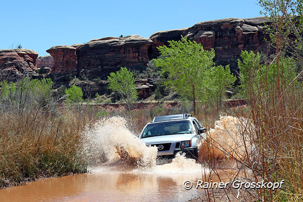
The formalities were completed quickly in the Visitor Center, and I got a paper with the combination for the padlock. The ranger also gave me a solid jute bag for the storage of my food. Thin plastic bags would be useless because they will not prevent mice or crows getting to the food.. Finally the ranger told me that the spur road to Peek-a-boo campground was partly under water, however the ground is solid and I should pass the water rather fast. This advice sounded much more harmless than the trip finally was.
After having closed and locked the gate at the entrance to the road behind me, I drove with my Nissan Xterra along the wash - not too slowly, because the track was quite sandy. After less than a mile I first saw what had been announced the ranger. From the track was nothing more to see, only water. As the track followed the winding creek, I could not see around the corner to check how far the track was under water. Never in my life I would be driving through the water with a rented car, if the ranger had not confirmed that the ground is solid. I was alone, the ground was very sandy and it was not clear how far the track was under water and how deep the water was - enough good reasons not to drive through there. But I wanted to go to the Angel Arch, and at least the ranger had said that it should work without problems. If I should really get stuck, help would not be too far away. So full power - and through! Having crossed a long distance in the water, sometimes with a large bow wave that sometimes spilled over to the windshield, I slowly lost my reservations. One should not stop in the water – so keep your foot on the gas. As the ranger had said, the ground was solid and so the ride was quite unproblematic, even though I drove almost continuously in water with different depths. When I came to meet another car, I even went a bit backwards through the water to reach an area where the cars could pass.
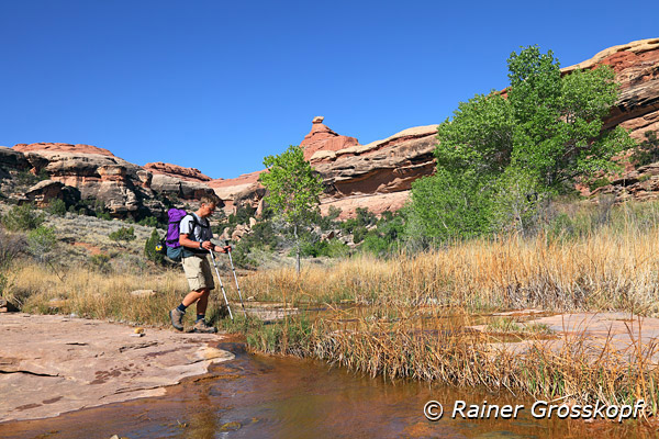
When I arrived at the Peek-a-boo campground it took some time to pack my backpack and get ready to start. It was noon when I finally started the hike. For the first time I carried the backpack with the full weight, including a water bag filled with 5 liters. It felt not so badly, but I was not yet hiked very far. I resolved to go quietly and slowly and make frequent breaks. Should I not make it to the campground today, it would be no problem because I had everything I needed with me.
Salt Creek
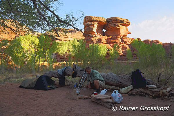
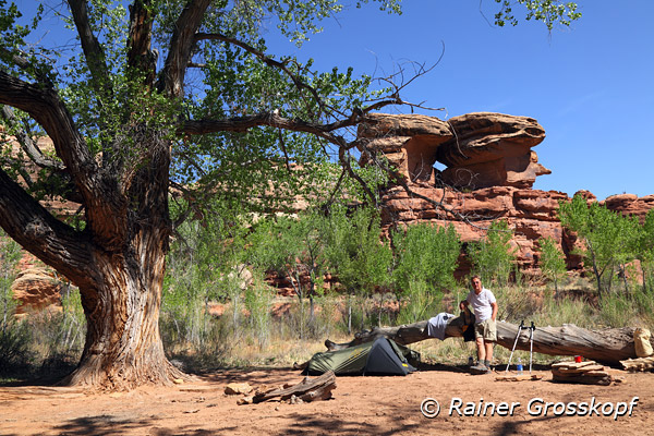
It was actually rather easy to follow the trail however I had stored some waypoints in my GPS to be on the safe side. All along the trail there was enough water in the creek, which reassured me, since I was uncertain where I could fill up my drinking water. The trail wound its way, always following the creek through a canyon with moderate high walls. It had become hot, around 90 degrees, but since most of the trail was pretty flat and I was not too fast, I had no problem with the heat despite of the heavy backpack. I walked along with moderate speed and made a drinking break every hour. After about 3 hours - I had just made a break to drink water - I reached a nice shady spot with a few tall trees that looked as if people had stayed here. I went on assuming it is still a long way to go to the campground, but a few minutes later I saw the sign that pointed to the Angel Arch. Now I first realized that I was already at the campground, respectively I passed it a few minutes ago. I was so sure that I would be rather slow with the heavy backpack that I did not at all expect to reach the campground so fast.
But the better - I turned around and walked back the short distance to the shady spot under the trees. My tent was set up quickly (I had practiced at home once), and the backpack was considerably lighter having stowed some things in the tent. Behind the trees, I discovered some metal canister in which I could store my food supplies. Since it was still relatively early, it was clear to me that I would go to the Angel Arch. Too great was my curiosity to see this place.
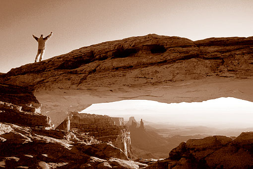
Angel Arch
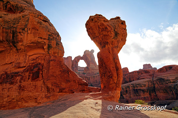
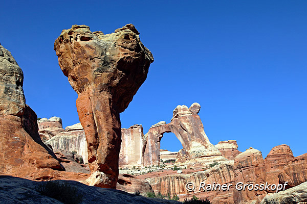
It was clear that the Angel Arch is more of a photo opportunity for the morning light, because it would stand in the back light now. Since I planned for the next morning to be at the Angel Arch at sunrise, it was actually helpful to see the trail in daylight, because the next day I had to hike in the dark, only with the light of my headlamp. With the now much lighter backpack I progressed pretty fast, although the trail led slightly uphill all the time. After about an hour, around 6 p.m., I reached the Molar (back tooth) from where you’ve got the "classical" view of the Angel Arch. I was excited - even in backlight the Angel Arch and the Molar were an excellent photo opportunity. After about an hour I went back to the campground.
Back at the campground I filled my 5-liter water bag with coarsely filtered water from the nearby creek. I added a few water purification tablets and over night the water will get ready to drink. With my little stove I cooked about 1 liter of water, enough to prepare a bag of dry food (I do not remember what taste) and a cup of coffee. With emerging darkness, around 9 p.m., I went into my tent and fell asleep. The alarm clock was set to 4:30, because I wanted to be at Angel Arch at sunrise.
Hiking to Angel Arch in darkness
I did not feel tired when the alarm clock rang at 4:30 a.m. I dressed in the glow of my headlamp, took my backpack and wanted to go. I would have my breakfast after returning from the Angel Arch. However, I was not well prepared because I had forgotten to commit the trail leaving the campground to my memory. I wandered around in the dark, but with the small circle of light from my headlamp I could not find the trail. I was angry because of my stupidity that I did not mark the trail somehow. Half an hour later, when it became a bit brighter, I finally found the trail. With a delay of more than half an hour I was on my way. After I had reached the sign pointing to the Angel Arch, it was no more problem to follow the trail, and soon I was able to go without the headlamp.
But getting up early was not worth it. It took a long time before the first rays of sun touched the top of the Angel Arch, and another hour before the sun was shining at the Molar. After extensive shooting I went back to the campground. It was still very early in the day, and after a breakfast with coffee and cereal bars, I decided to hike to the All-American-Man pictography.
Upper Salt Creek
I was well aware what I planned to do, because the path along the Upper Salt Creek to the All-American Man and back would mean I would have to hike nearly 20 miles. In addition to the cameras and the tripod, I put a couple of power bars and the water bag filled with 4 liters in my backpack. Finally, the water bottle with the coarse particle filter and a few tablets for water purification came in the backpack. Then I went off, always following the Salt Creek. There was much more hiking up and down now as on the first part along the Salt Creek. In some parts the Salt Creek had eroded a deep canyon into the sandy soil, making it impossible to stay in the creek, and the trail climbed up the bank of the creek to pass the canyon.
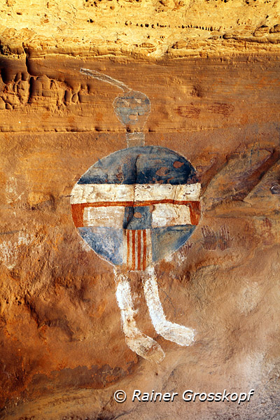
This time, I experienced exactly the opposite as the previous day. I confused the campgrounds, where I came by and thought I was much further than I was in reality. The greater the disappointment when I realized that I still had to go pretty far yet. Just before the Salt Creek Canyon widened into a broad flat plain, I met other people for the first time on my hike. It was the group of Americans, some of whom I had met at the Visitor Center. I asked them how far it was to the All-American Man and in particular, if it could be a problem to find the pictography. The pictography was in a small cave and I did not want to pass by without finding it. Unfortunately, I stored several waypoints in my GPS, but I did not mark, which one is the All-American Man. It reassured me that the Americans said that I can’t miss the All-American-Man, because a metal canister containing some brochures was placed in front of the cave with the pictography.
Soon I crossed the small falls of the Upper Jump of the Salt Creek, a good place to fill up water, even in drier times. I planned to fill up my water supplies here on my way back. The landscape had changed completely since I came out of the canyon - it looked now like a kind of prairie. Shortly thereafter, I saw the sign for the Camp SC-3, and I now knew that it could not be too far.
All-American-Man pictography
It was not far, but nevertheless I almost reversed without finding the All-American-Man. When I came to a place where a rocky ridge came rather close to the Salt Creek, I knew from the map that the All-American-Man could not be far away. However, the trail did not lead around the ridge, but along the ridge to the top. I was already pretty tired from the long hike and hiking uphill the steep ridge exhausted me. Every moment I expected to see the metal canister - the cave must be here somewhere in the rocks. Even my GPS pointed to the rock wall and showed a distance of 50 - 100 m, what I interpreted as a small inaccuracy of the coordinates. Soon I put down my backpack in order to better investigate the area – I should be able to find the canister and the cave!
|
|
There was a great crack in the rock cliff and one could go to the other side of the ridge where it went down sharply. This could not be the trail, but the cave must be here somewhere. However, after a while I gave up my unsuccessful search and went back down the ridge to the Salt Creek. According to my map the trail should lead here around the ridge. But that was impossible, because the Salt Creek had washed out a deep canyon in the sand, making it impossible to pass around the ridge.
Disappointed I wanted to turn back, when I suddenly had the enlightenment that a new trail is probably leading across the ridge because it is impossible to pass the ridge at the level of the Salt Creek. So again I hiked panting uphill. The crack in the rock cliff is the only possibility to get to the other side of the ridge - hence I have to go through it. Climbing through the crack was not that bad as I had expected, and when I reached the bottom at the other side of the ridge I found the trail again. I followed the trail just for a minute when I saw the metal canister – it could not be overlooked.
Now there was only one more problem - how do I get into the cave to take pictures of the All-American-Man? From below the cave you can see the pictography, but it is impossible to take a good picture from that point. It was about 3 m to climb up to get into the cave – a bit risky when you are alone. So, I took off my backpack and hang just a camera around the neck. The tripod could easily be pushed up into the cave. Fortunately, everything went well, because if I had injured myself, I would eventually be helpless for some time before anyone came passing by. |
Back to the camp
The way back is long and arduous, because now I felt that I had hiked a lot in the past few days. At the Upper Jump I filled up my water bag with 2 liters and some purification tablets. After 1 or 2 hours the water would be processed and drinkable. About an hour before sunset, I was back at my campground. There was still enough time to prepare some water for the next day and boil some water for a bag with dry food. I have not seen the Americans who I have met on my hike - probably they camp somewhere else.
For the next morning I had envisaged another visit at the Angel Arch, but I was a bit tired and I did not really know why I should hike again to the Arch. The weather was the same, without any dramatic clouds, so I didn’t see any reason to take more pictures at the Arch. My permit was still valid for a few more days but I had already made all the hikes and photos that were planned. So, I packed my stuff together without any hurry and started slowly my hike back to the Peek-a-boo campground where my car was parked.
After 3-4 hours I was back at the car. The road along the Salt Creek was still under water. However, now I was more courageous than on first day and on the way back through the water I took a few pictures with my remote control. I reported to the Rangers that I am back and I returned the jute bag and also my permit. The permit could now be used by others in case someone came in spontaneously asking for a walk-in permit.
>> more pictures |